Hoegee's Loop
Hiked: July 2, 2006
BF and I got a late start on Sunday morning. We aren't accustomed to waking up in the A.M. on the weekend, so dragging ourselves out of bed by 8:30 for the hike was a tad unsettling. We cooked eggs and leisurely sat around the apartment, trying to figure out when and where we were going.
Our friends WC and NO had considered joining us on this trek, but NO hadn't called, which meant she wasn't coming, and WC had trepidations. BF and I hadn't decided on a specific hike by 9:30 (so many to choose from!), and he wasn't able to dedicate his whole day to schlepping around the Angeles National Forest, so WC passed on the hike as well.
Down to just BF and I, we finally had to decide on a hike. Initially, BF wanted to go to Mt. Baden-Powell. I was worried that it was too far away (possibly 70 miles, depending on which you go), and also that it would be too strenuous for a "first" hike.
I've done a lot of hiking in my life, but I have to say that I've been relatively sedentary for the past few years. I'm a writer and do web coding and design to make money, so most of my day is spent in front of a computer. BF and I acquired a free treadmill from craigslist a few months ago, and I had been making efforts to use it regularly until about two months ago when it spontaneously stopped functioning. Mr. Treadmill still ran, but he slipped and screamed whenever you started to walk faster than four miles per hour. BF and I have been trying to fix him---we've made some major breakthroughs in the past week---but for now he's gathering dust (and taking up space) in our living room.
I've used the broken treadmill as an excuse not to exercise for far too long. The problem is that I hate the concept of exercising. I have major hang-ups about exercising in public---I'm not sure why, but I assume everyone's criticizing my technique and judging me---and it's not easy to exercise in your living room sans Mr. Treadmill. Though I hate exercising, I could hike forever and I never think of it as "cardio."
So seeing as I am slightly out of shape, we decided to hike "Hoegee's Loop" as describe in Top Trails Los Angeles. The book promised shade, a "2 out of 5" difficulty level, and approximately 5.3 miles of trail.
From our abode in Echo Park in East L.A., it only took 20 minutes to drive to Chantry Flat, the starting (and ending) point of the hike. After pruning the contents of our backpack to three liters of water and a small collection of varied nutritional bars, we headed on the trail. I carried the camera case, and BF had the heavy backpack.
The loop was planned as follows:
- Leave Chantry Flat via the "First Water Trail"
- Arrive at Roberts' Camp
- Take the "Lower Winter Creek Trail" to Hoegee's Camp
- Leave Hoegee's Camp via the "Upper Winter Creek Trail"
- Arrive back at Chantry Flat
The initial descent to Roberts' Camp is a gently twisting, quite steep asphalt road. At 12:30 in the afternoon, the heat from the sun radiated off the road insidiously. BF and I noted how unpleasant it would be to return on the steep road. There were a fair amount of people making their way up the road, and you could see the anguish in their faces as the slowly passed by. We descended into the Santa Anita canyon rapidly, the hills towering over us as we walked. After about a half mile (these are all completely uneducated estimates), we found ourselves in a shady landing. A sign pointed towards Hoegee's Camp in one direction and then towards the First Water Trail in the other. Thinking we were at the terminus of the loop. BF and I headed toward the First Water Trail, as it was the first trail listed in our guide.
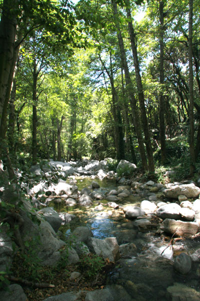
We walked downstream for about a mile, enjoying the shade of the trees and the scattered 1920s-era cabins that still sit streamside. This is a view from the First Water Trail:
According to the guide, we had to take a left at some point and go upstream. We couldn't figure out where this would happen. We had been heading downstream for a mile, and there was no sign of the trail turning the other way. We ventured a bit further, along a narrow, cliff-hugging path until we arrived at a small swimming hole. There were a few people jumping off the rocks into the pool below:
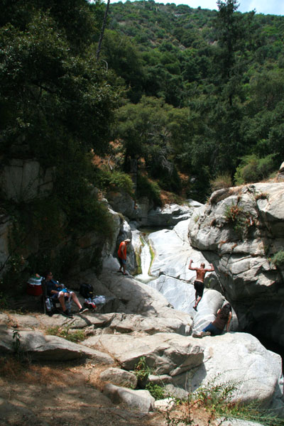
Of course, those people jumping into the water were also drinking beer. I marveled at their casual attitude towards impending quadriplegia, and BF observed that carrying an ice cooler along that crumbling trail required a noted lack of common sense. Either that or a raging case of alcoholism. Either way, BF and I decided we should leave before we were witnesses to a drowning.
Consulting our map, we realized our problem. Rather than take the long paved road to its terminus, we were supposed to cut off onto an "obscure trail" about .2 miles from the start. Amazed that we somehow missed the "obscure trail," we then saw that we just picked up the First Water Trail at Roberts' Camp. We had simply been backtracking. BF and I dutifully turned around and made our way back to Roberts' Camp, which added about a mile to our trip. The trip back to Roberts' Camp was completely uphill and upstream, but we were still shaded and we only passed one or two hikers, so our hiking experience was still a pleasant one.
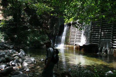
Back at Roberts' Camp, we followed the trail marker towards Hoegee's Camp. According to our book, Hoegee's Camp was a gold mining operation from the 1850s-1950s. We were told there would be interesting detritus left over from the mining operation. The Lower Winter Creek Trail took us toward our destination, 1.5 miles ahead. The trail was well-worn, easily followed, and mostly packed dirt. There were a few easy river crossings. The trail wound its way uphill around multiple concrete dams:
The trail was a bit relentlessly uphill. Though the book only claims 1300 feet are gained and lost in this hike, they are all done fairly quickly. The descent down to Roberts' Camp is rapid, done in probably less than a mile, and then at least 2 miles are straight uphill. The grade is forgiving, but it did make sedentary me sweat just a tad.
When we arrived at Hoegee's Camp, we saw the aforementioned "detritus" from the mining operation. There were a few US Forest Service issued camping stoves lying around. Most notably, there were the remains of some sort of building, with a stove or fireplace still intact:
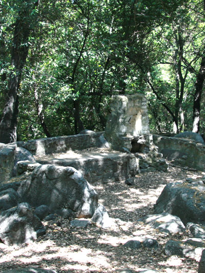
Being the spoiled brat I am, this didn't really pass muster as real "history" for my sensibilities. I've been to Europe---now those old buildings are historical. But I suppose history in Southern California only dates back to whenever someone devised a way to get water down into the desert they now call Los Angeles, so the remains of Hoegee's Camp would qualify.
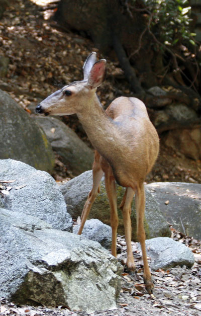
BF ran off to the outhouse for a moment and I decided to poke around the campsite a little more. I walked over to get a better picture of the stone building when I saw:
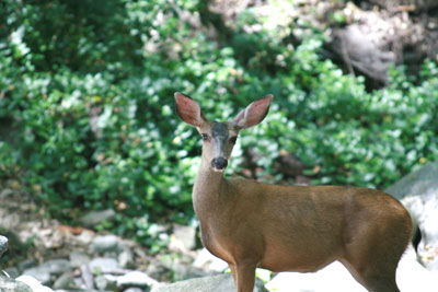
Lil' Miss Deer was looking for some good greens to eat when I happened upon her. I was convinced she'd bolt the minute I took a picture, but by the time BF returned from the loo she was still standing in front of us. BF and I proceeded to take pictures of her for the next 15 minutes.
Eventually, we decided to leave her alone and get trekking on our hike. We were about to pick up the Upper Winter Creek Trail, and we were looking forward to some walking downhill.
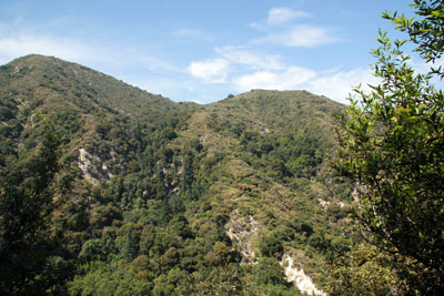
Unfortunately, we had some delayed gratification with the Upper Winter Creek Trail. It continued to snake uphill for another half mile or so (much to my chagrin), until it leveled off above the canyon. Though the trees were thick, we got a few good views of the canyon we had just emerged from:
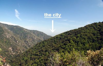
Eventually, after a close call with a bee hive, we could even see the city in the distance.
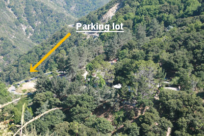
The path slowly meandered downhill, with nice but not extraordinary views, for quite some time. Finally, we could see the parking lot:
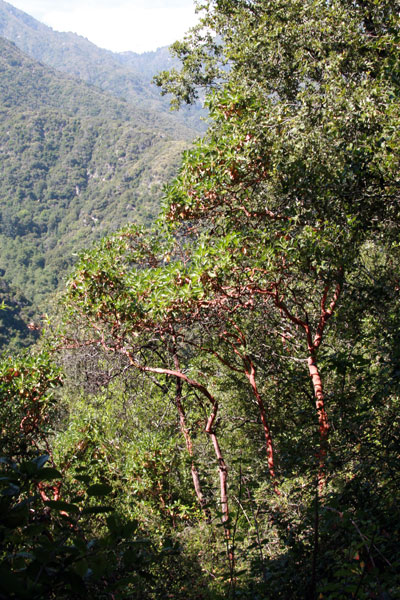
BF liked how these trees looked (they were quite red in "real life"):
The best part of choosing to do the loop was that we never had to ascent that horrendous asphalt road. The Upper Winter Creek Trail dropped us off on a fire service road, which then plopped us on the opposite end of the parking lot from where we departed. We found our car and drove home, by way of CostCo, and thus ended our first hike in L.A.
Summary Judgment
Pros:
- Nicely paced walk, easily finished in an afternoon
- Close to the city/Short drive
- Shaded almost the entire way---great for a hot day
- Trail is well marked, easily followed
- Cool stream runs along the first few miles, great for head-dipping
Cons:
- Views not particularly spectacular
- Historical importance overrated
Conclusion:
- Well worth the trip.
If you'd like more detailed information about the hike, including topo maps and specific mileage information, check out Dan's Hiking Pages and Top Trails Los Angeles, the book we used for this hike.
posted by iwriteplays @ 4:12 PM
![]()


1 Comments:
This is awesome. Everything I needed to know before hiking this myself! Thanks so much!
Post a Comment
<< Home