Mount Lowe
Hiked: July 8, 2006
Once again, BF and I got a late start hiking. We set our alarms for 9 a.m., hoping to wake up bright-eyed and bushy-tailed, ready to set off towards... well, the first problem was that we didn't know where we were hiking. The night before, we both sat around reading our various hiking books while watching TV (me) and playing internet poker (BF). Needless to say, we didn't come to a conclusion on where to hike.
After pressing snooze for about an hour, I got a call from my good friends N&N. Apparently N&N were at the Brite Spot, a fabulous diner around the corner from my apartment, and they were wondering if BF and I wanted to join them for breakfast. We did. BF, N&N, and I had a leisurely breakfast---so much so that the waitress had to kick us out because she "needed the table." Then we all walked down to the park to check out the Lotus Festival, an annual celebration of Asian and Pacific Islander cultures.
Eventually, BF and I realized that if we were going to hike, we needed to stop lollygagging and get our butts on the mountain. N&N needed to get back to their lovely dog, Katie, anyway, so we parted ways. Before N&N left, though, we promised to hike to Dawn Mine together soon.
Back at the apartment, BF and I nearly didn't make it out to hike. I flopped down on the couch, and he parked himself in front of the computer. Once again, we were both lazily thumbing through hiking books without making anything resembling a decision of where to hike. Somehow we peeled ourselves away from lethargy and got out the door. I made the final decision to go to Mount Lowe. The book said it was a 3.2 mile hike, with approximately 500 feet elevation gain/loss. Seeing as it was almost 2 p.m., and would probably be 3 before we got to the trailhead, I figured an easy hike was the way to go.
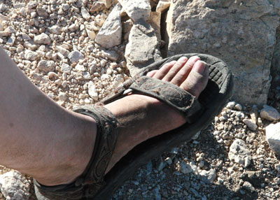
Because this seemed like an easy hike, I decided to wear my Tevas. Flash forward to 6:30 p.m. and my feet looked like this:
But I'm getting ahead of myself.
To get to Mount Lowe, you take highway 2, also known as the Angeles Crest Highway, about 14 miles from La Cañada, then you turn and go 2.4 miles up Mount Wilson Road. We ran into our first snag about 3 miles up the Angeles Crest Highway. We had been coasting along, enjoying the fabulous views and bright sunshine, when we saw a ranger holding up a stop sign on the side of the road. She gestured ahead of us, and we saw that there was a growing line of stopped cars in our path. We dutifully stopped and speculated on the cause of the backup. I thought maybe a rock slide had blocked off a lane of traffic. I was wrong. After four emergency vehicles screamed past, sirens blaring, and a ranger search & rescue helicopter started circling ahead, we figured out there had been an accident. The helicopter landed just past the curve in the road. People started turning off their engines and getting out to see what all the hubbub was about:
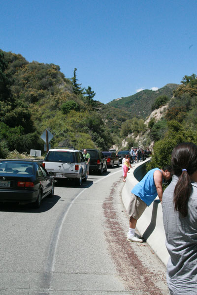
Inquiring minds walked ahead to see the wreckage, and reported back that there had been a motorcycle crash. About 20 minutes later, the helicopter took off again, and a tow truck carried the wreckage of the motorcycle down the mountain, and the emergency vehicles puttered off. We were allowed to drive again.
I want to take a second and say just how beautiful the Angeles Crest Highway really is. Though I was driving and couldn't gaze at the mountains for extended periods of time, I thoroughly enjoyed the drive to Mount Lowe.
We arrived at the trailhead and got cracking on our hike. The first part of the hike follows an unused fire access road. The road hugs the side of the mountain, and then goes through a large tunnel:
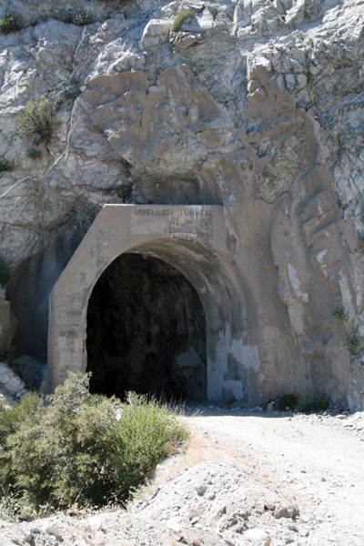
The inside of the tunnel was covered in concrete, presumably to stop the rock from breaking off and hitting us in the head. BF and I both noted how "fake" the contouring inside the tunnel looked. It was very Disney-esque. I've noticed this in nature elsewhere, too. Sometimes forests look scarily like the fake trees you see in theme parks. Or real granite rocks look like they're made out of chicken wire and sprayed-on plaster. What's particularly disturbing about this is that I find myself comparing the real world to manufactured reality, but I'm using the fake example as the standard. I don't go to theme parks and say, "Wow! Those look like real rocks!" I got into nature and say, "Wow! Those look just like the ones at Six Flags!"
And this is why I'm trying to hike more. Real world = good. Fake world = entertaining, but still fake.
Back to the hike. About a half-mile down the fire road, you take a left and go up a dirt hiking trail. I was pleased because this trail was mostly shaded. BF and I spotted some big fat lizards and consistently great views. I have to say that the views are spectacular right from the beginning. Hell, where we parked there was a great view of Mt. Baldy in the distance. You can't go wrong with this hike.
Another mile or so and we were almost done with the first leg of our hike. We had barely broken a sweat. I looked at our book, and there was a short mention of "adding 2 miles" to the hike by taking the East and West Mount Lowe trail around the mountain. That path would loop us around to the peak, then deposit us back where we started. There was a little diagram of the loop, but no topographical information. We decided to do it.
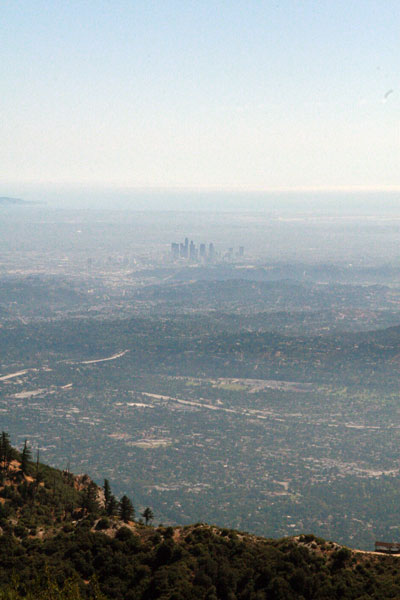
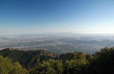
We started to loop around the South side of the mountain. The views of the L.A. basin were stunning. I then decided that I would have to come back up to Mt. Lowe the next time the smog lifted (or got blown/washed away). Even though the day was a bit hazy with pollution, we could still see all of Los Angeles, all the way to the ocean:
As the East Mt Lowe Trail continued on, we started to lose elevation quite fast. I started to become concerned that my Teva-clad feet weren't up for this trip. There were a few really slippery and rocky spots where closed-toed shoes would have been welcome. I even slipped and fell once or twice. (I have a gnarly bruise on my leg and a sore hand, but no serious dings.) After about a mile of steady descent, BF and I arrived at the West Mt Lowe Trail.
Guess what? What goes down must come up. The next mile or so was all uphill, and fairly steep in sections. I had to take it slowly. BF was very patient with my huffing and puffing. I was turning red, I think. I even thought, "Now this is cardio!"
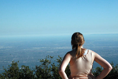
Not a moment too soon we arrived at the rocky peak of Mount Lowe. There was even a rickety bench for me to sit on. After a good long drink of water, and finishing some fruit leather (I think I had low blood sugar), I stood up to look around. Here's me looking out over L.A.:
Here's the view facing North from Mount Lowe. (One of these peaks is called "Mount Disappointment". I like that.):
Another view of the L.A. basin from the top:
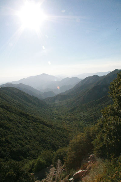
After soaking in the views for a while, BF and I headed back down the trail. This leg of the trip was refreshingly easy, all gradually downhill and no tricky rocky spots. About three-quarters of a mile from the trailhead, there a great sweeping view of a valley. (I was trying to be artistic, getting the sun flare in the picture.)
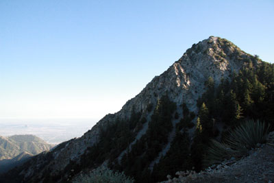
Once we regressed through the Disney-tunnel, we got a clear view of Mount Lowe's summit:
It's always nice to look back and say, "Wow! We were just at the top of that mountain!" The best part of the Mount Lowe hike is that you can do this on a fairly easy trail and in an afternoon.
Summary Judgment
Awesome trail. I don't have anything negative to say about it. Beautiful views, great trails, customizable for length and difficulty. Even the drive to and from the trail is nice. I'll be returning on the next clear day.
posted by iwriteplays @ 2:06 PM
![]()


2 Comments:
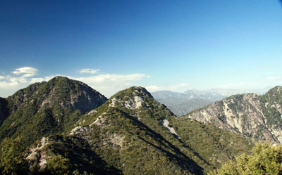
The picture entitled "Once we regressed..." is not Mt. Lowe. That is Mt Markham. You hiked right past Markham to get to Lowe. Mt Lowe is behind it (south west) and over 800 ft taller.
The pictured entitled "Here's the view facing North..." does not show Mt Disappointment. Close though. Centered in the foreground is Mt Markham. Behind it and to the left is the tallest peak in the front range, San Gabriel Peak. If your picture went to the left just a little bit you would then see Mt Disappointment.
Glad you had a good time. Looks like good weather– fairly clear.
That tunnel was part of the old Mt. Lowe railroad ... Hard to believe there was once a railroad to Mt. Lowe.
http://en.wikipedia.org/wiki/Mount_Lowe_Railway
Post a Comment
<< Home