Malibu Spring
Hiked: August 5, 2006
What is it those pesky Boy Scouts always say? "Be prepared"? It's a good idea in theory, but in real life you can never be fully prepared. Sure, you can try to prepare for all foreseeable scenarios. But when hiking, this makes for a very heavy backpack. What "be prepared" really means is: have some useful supplies, and be resourceful when those supplies aren't enough.
By this standard, BF and I were "prepared" for our hike on the Malibu Spring Trail. (I am here to tell the tale, after all.) By all other standards, though, we were woefully under-prepared for our adventure. There were a few key things we lacked.
Things We Lacked:
1) An early start. As usual, BF and I had mitigating circumstances that prevented us from getting out to the trail early. The official explanation for our late start was this guy:

His name is Peter, and he was one of our foster cats. BF and I have been taking in foster cats for the Southern California Siamese Rescue (SoCSR) for a few months now. Peter had been adopted by a woman in Phoenix, and someone from SoCSR came by to pick him up to take him to his new home.
Of course, I call this the "official" reason because Peter was in his carrier and on the road by 9:30 a.m. The real reason BF and I got a late start was because we decided to go back to sleep after Peter left.
2) A proper map. We had very sketchy directions to the trailhead. We would have missed it, but a nice resident of Malibu, noticing our navigational distress, pulled over to show us to the right place. When he asked where we were going, I told him "Nicholas Pond, via the Malibu Creek Trail."
"Oh, you're way off!" He proclaimed. I didn't believe him. I knew we hadn't found the trailhead, but I also knew we were on the right road. Nice Resident disagreed. But when I showed him the Google map of the site, he relented and said we had just passed it. But he did question our judgment.
"That's the long way to get there. It's like 3 miles straight up that hill. You don't really want to do that, do you?" He protested. We assured him that yes, we did want to hike up that hill, and though he raised his eyebrows, he didn't stop us. He did warn us that there were "a lot of ticks" on that trail, and we definitely needed long sleeves for the hike.
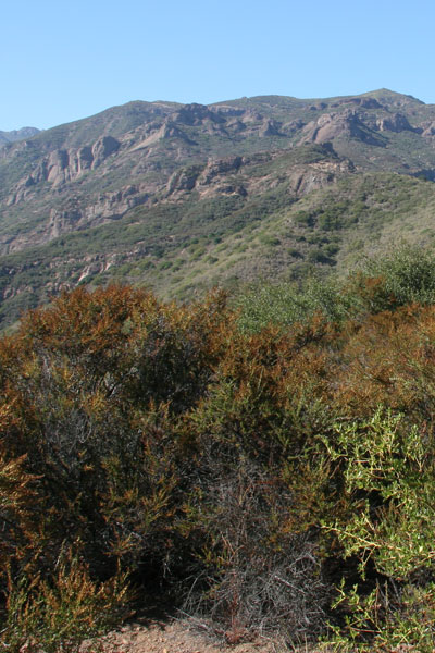
3) Long-sleeved shirts. Though I had read some of the trail reviews on LocalHikes, I didn't think the conditions would be bad enough to merit a long-sleeved top. In a rare moment of foresight, I did somehow manage to put on long pants and remind BF to do the same. When we arrived at the trailhead, BF and I saw why covered limbs would be preferable. The trail was beyond overgrown. A chain-link fence marked the beginning of the "Malibu Creek Trail." There was some remnant of trail at our feet, but everything ahead of us was dense foliage, with the occasional cleavage indicating where the path would lead. It looked just like this:
If BF and I hadn't been wearing long pants, we would have turned around immediately. But since most of the brush had only metastasized to armpit-level, we decided to give it a go. It was 4 p.m., after all, and if we wanted to finish this hike before dark, we'd have to get on our way.
Because of all the stories of the hike being "ticky", BF and I ended up developing our own obsessive-compulsive tics along the way. Whenever we had an intimate encounter with a bush or a tree, we would systematically wipe our hands over all exposed skin areas. Because the flora on the non-trail was so ubiquitous, we had to do this more or less continually during the first two miles. We probably looked like escaped mental patients---luckily there was no one to witness our perpetual gesturing. I probably got an upper-body workout, too. There's always a silver lining. Always.
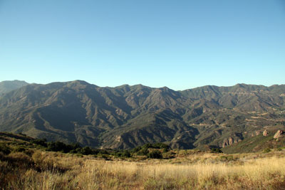
4) A navigable trail. Calling this a "trail" is generous. Because of all the unruly plant life, finding the right path was mostly guesswork. BF and I were wandering more or less blind for the majority of the afternoon. After about two miles, we found ourselves at a nice overlook of the Santa Monica mountains:
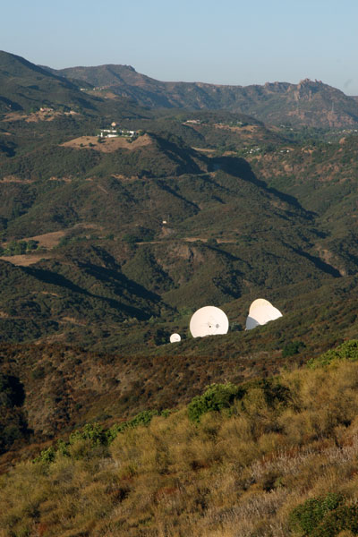
There were also these monstrously large satellite dishes watching us:
We had printed out the topographic map of the trail from LocalHikes:
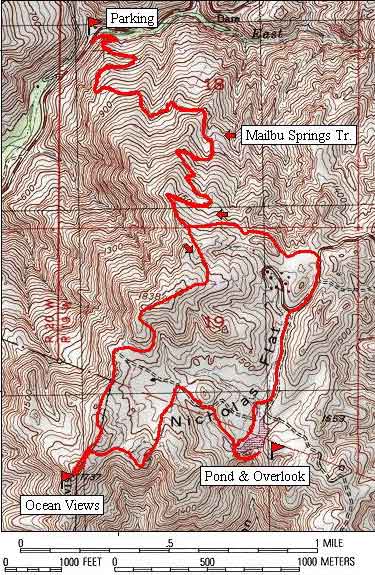
According to this map, we were supposed to come to a junction where we'd take a right, head out to a nice "ocean view", then continue on to the pond.
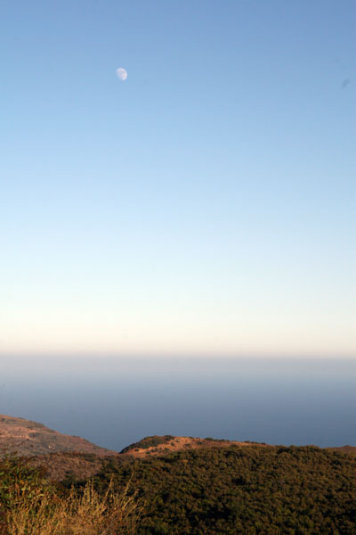
BF and I hadn't realized we were off the trail until we arrived at a golden meadow, with no discernible path in sight. BF decided just to head up the hill, his logic being that we were supposed to be going up, so "up" is where we'd go, trail or no trail. I followed him at first, then I got cold feet and insisted we return to the meadow to look for a real trail. When we didn't find one, I defaulted to BF's logic and followed him up the hill. Lo and behold, we found what appeared to be a real hiking trail at the top of the hill. I thought we were home free. We took a right and eventually came to an actual trail marker. This must mean we're in the right place, I thought. I was wrong. We took a side trail up to what we thought was the "ocean view". It turns out there was a view of the Pacific at the top:
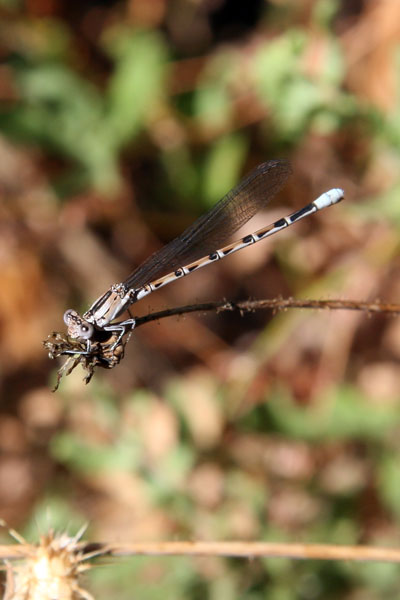
But then BF and I decided this couldn't have been the right overlook, so we continued on a promising-looking trail off to our right. After about a mile, and after descending a couple hundred feet, BF and I reëvaluated our options. We turned back and decided to find the trail marker again and go from there. Somewhere in all this backtracking, BF got a shot of a little dragonfly:
We found the trail marker and I decided, using my ever-evolving theory about our location, to head right. Going right was my default plan. Because the trail was completely impossible to decipher, going right was as good a plan as anything. Finally, we got to another meadow that was right next to a paved road and I figured we were close to Nicholas Pond. After circling around the meadow a few times and not seeing the pond, we spotted a couple parked on the road and asked for their guidance. They pointed us down the road and said they pond was that way. I suggested to BF that we just scrap the plan and turn around. BF is somewhat goal-oriented, and having come all this way to not see the pond was not in the cards. We were going to see the pond. So we headed down the road.
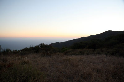
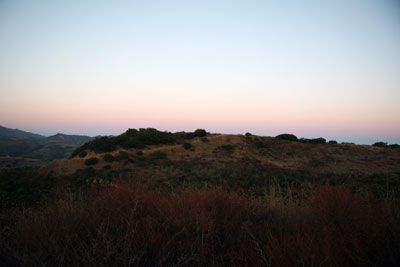
5) Daylight. It was becoming increasingly clear, as we walked down the road towards the fabled Nicholas Pond, that the sun was setting. Luckily, BF had his headlamp and I had thought to pack my own flashlight, so a little night hiking wouldn't be a total disaster. We came to another trailhead and pushed onwards. Another mile passed and we hadn't found the pond, though we did see three deer leaping across the meadows! BF tried to get a shot, but they were too quick for him. However, he did get these pictures of the sun setting:
With the sun setting, and something like four miles to trek, BF and I switched into super-hiker mode. We whipped out our flashlights and booked it down the mountain.
Finding our way back down the mountain through the thick brush was not a task for the lighthearted. Because BF led the way up, it was only natural for him to lead us back. The only saving grace was that the moon was large and bright in the sky, so it wasn't pitch black surrounding us. But it was pretty close. BF whipped through the overgrowth, figuring out the trail using what seemed to be hiker's ESP. I was absolutely certain we weren't on the trail more often than not---everything looked different at night.
We walked as fast as we could down the mountain. BF, being in the lead, had noticed a few spider webs straddling the "trail" on the way up. Apparently the critters had been very busy while we were gone, and BF had to stop at least a dozen times to avoid getting a mouth full of spiders. So many had made their webs directly across the trail that BF had to use sticks to clear our path. It was unsettling, to say the least.
Just as BF's m.o. had been "just head up" at the beginning of the hike, my mantra quickly turned to "downhill equals good." I didn't care if we ended up at the right trailhead, I just wanted to find myself somewhere along Mulholland Highway. Though I was skeptical, BF insisted he remembered parts of the trail. A rock was familiar, a turn rang a bell. I remembered nothing. Just when I was absolutely sure we had lost the path... a chain link fence! We had made it! It was 9:30 p.m. What had taken us four hours to do on the way up, we had conquered in less than two and in the dark.
Before we left, BF and I looked each other over for ticks (we had found two on our clothes earlier, but that was it), and I gave BF the kudos he deserved. We wearily climbed into the car and drove home. En route, we picked up a fabulous meal at an In-N-Out Burger in Studio City, and then promptly got stuck in traffic. I was so hypoglycemic when I got home that I couldn't even eat my double-double. I had a massive headache and the thought of food made me nauseated. I forced a quarter of the burger in my mouth, popped a bunch of ibuprofen, and passed out on the couch. Twenty minutes later, I woke up and devoured the rest of my burger and animal-style fries. I had recovered. THE END.
posted by iwriteplays @ 2:28 PM
![]()


0 Comments:
Post a Comment
<< Home